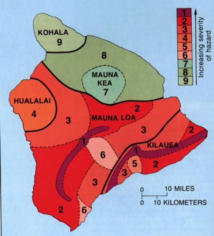
Lava Hazard Zones
It is important to remember that the map and table show a historical analysis of past volcanic activity and not a prediction of future threat.
Lava flow and activity is not a threat to life. It is, however, a threat to property that is covered under most standard homeowner's insurance policies.
It is important to remember that the map and table show a historical analysis of past volcanic activity and not a prediction of future threat.
Lava flow and activity is not a threat to life. It is, however, a threat to property that is covered under most standard homeowner's insurance policies.
Living near the California fault zone, the Central U.S. flood plane, the Midwest tornado alley, or the East Coast hurricane belt would all put you at far greater risk than living in volcanic hazard zone 1.
For more information about Hawaii Volcanoes visit the Hawaii Volcanoes National Park Web Site.

| Zone | % covered by lava since 1800 | % covered by lava in the last 750 yrs | Explanation |
| 1 | > 25 | > 65 | Includes the summits and rift zones of Kilauea and Mauna Loa where vents have been repeatedly active in historic time |
| 2 | 15-25 | 25-75 | Areas adjacent to and downslope of active rift zones |
| 3 | 1-5 | 15-75 | Areas gradationally less hazardous than Zone 2 because of greater distance from recently active vents and/or because the topography makes it less likely that flows will cover these areas |
| 4 | about 5 | <15 | Includes all of Hualalai, where the frequency of eruptions is lower than on Kilauea and Mauna Loa. Flows typically cover large areas. |
| 5 | None | About 50 | Areas currently protected from lava flows by the topography of the volcano. |
| 6 | None | Very little | Same as Zone 5 |
| 7 | None | None | 20% of this area covered by lava in the last 10,000 yrs |
| 8 | None | None | Only a few percent of this area covered in the past 10,000 yrs |
| 9 | None | None | No eruption in this area for the past 60,000 yrs |
Additional Info
- Published in Big Island


